kottke.org posts about subway
The NYC Dept of Transportation is introducing compass decals to be placed on sidewalks at subway exits to help orient disembarking passengers. I thought I’d posted a link about this idea before on kottke.org, but the only reference I can find is a discussion about compasses on manhole covers. (thx, erik)
Update: Aha, here’s the entry. John has more.
The top 11 underground transit systems in the world. The London Tube is #1, NYC is #7, Hong Kong is #10. (via rob)
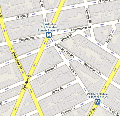
Not sure when these features were added, but Google Maps now displays public transportation stops (NYC subway, the T in Boston, the L in Chicago) and building outlines for metropolitan areas. Here’s a shot of the West Village in NYC:

Tiny but useful improvements. (thx, meg)
Photos of patterns taken from public transport vehicles. Gotta make it ugly enough to hide the stains, I guess.
Wesley Autrey jumped in front of an oncoming subway train to save the life of a man who had fallen on the tracks. I read this before I left for work yesterday and imagined the scenario when my train pulled into the station. I’d hope I would do the same thing as Mr. Autrey did, but that train moves awfully fast…
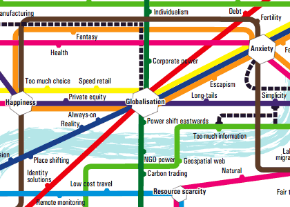
A pair of trend maps for 2007, both based on subway maps. The top one depicts the top online companies/brands & how they’re connected while the bottom one deals with ideas (with the River of Consciousness standing in for the Thames).


Both maps were found in this article about internet predictions in 2007. I don’t know about you, but I find these types of maps fun to look at, but completely inscrutable informationally speaking. Surely there’s a more enlightening way to present this information than in Tube map form.
Santas riding the NYC subway in 1987. Seeing graffiti on the subway always amazes me.
Prewalking: walking down the subway platform so that when you board the train, you’ll be close to the exit or transfer point when the train reaches its destination.
Update: Photo of the Way Out -> tube map, which marks which side of the train to exit from and where exits/transfers are for each station. (thx, tom)
Update: Exit maps are available for the Toronto and Toyko subways. (thx, adam)
Michael Frumin tried to get some NYC subway data from the New York City Transit Authority through Freedom Of Information Legislation for a project he wanted to do, but they denied his requests. “Given a database of anonymized Metrocard ‘swipes’ over some small period of time, Frumin imagined that a multitude of explorations could be embarked upon. Below is a concept sketch for one specific project idea — a visualization, for each station in the system, of the range of locations in the city that people travel to from that area.” Nice Minard-esque prototype map.
Morning subway demographics in NYC. Early morning blue collar workers give way to late morning white collar workers. (via capn)
Old 70s song about the subway from Sesame Street. This went totally over my head as a kid, but as a NYC resident, it’s awesome. On the subway. Subway!
Set of photos depicting NYC in the 80s. Everytime I see pictures of subway cars covered with graffiti, I marvel at how clean the cars are now.
Responses to People on the 6 Train That Hopefully Convey My Feelings in a Polite Way. “Thank you for so gently cupping my ass when we came to a stop.”
Update: The author of this list has a blog with some quick-witted observations of NYC. (thx, robert)
Newer posts
Older posts


Stay Connected