kottke.org posts about cities
This might be my new favorite skate video? It follows a pair of young skaters around the city as they chat about their friendship, share tips about living life, and try skating everything that is even remotely skateable.
Best friends, Ari and Luca are two of the most promising NYC talents right now. They are consistently street skating, crushing events, and are keeping skateboarding exciting for a generation we seemingly missed.
If these two stick with it, we have no problem betting that they’ll be the next big names out of the city, and we were lucky enough to catch them right before they arrive.
(via craid mod)
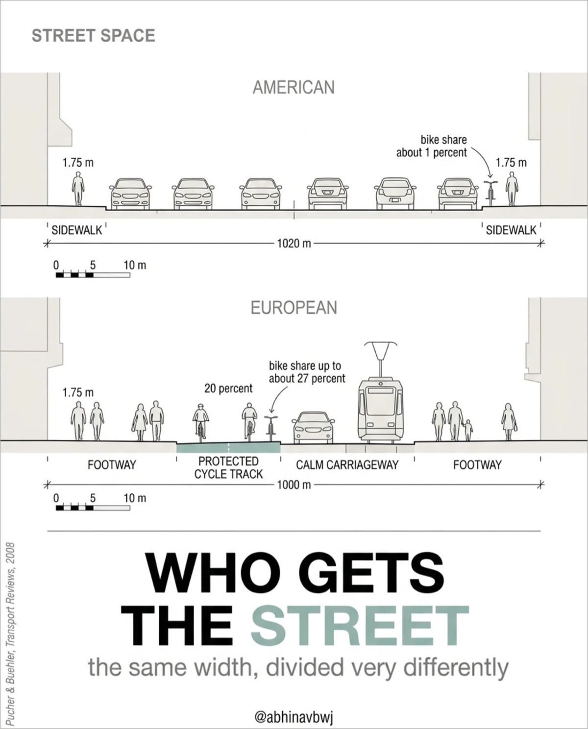
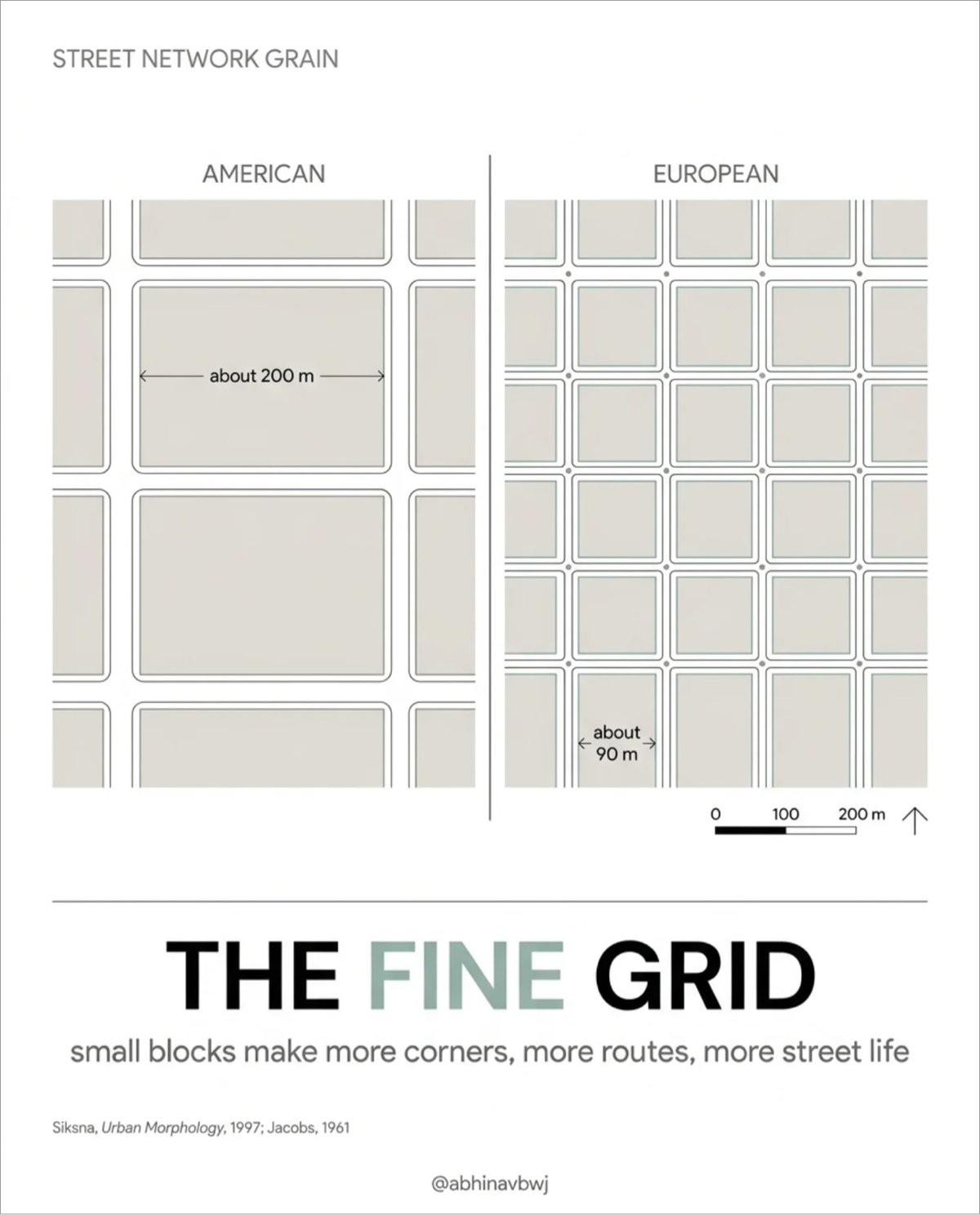
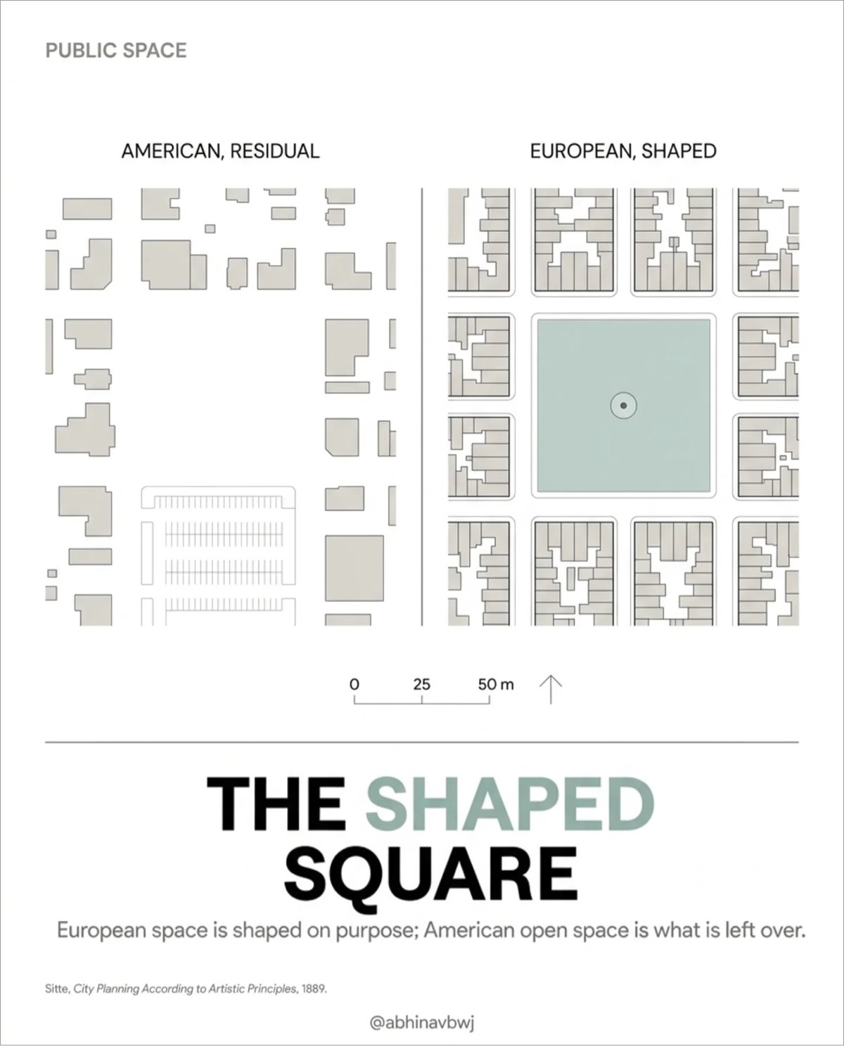
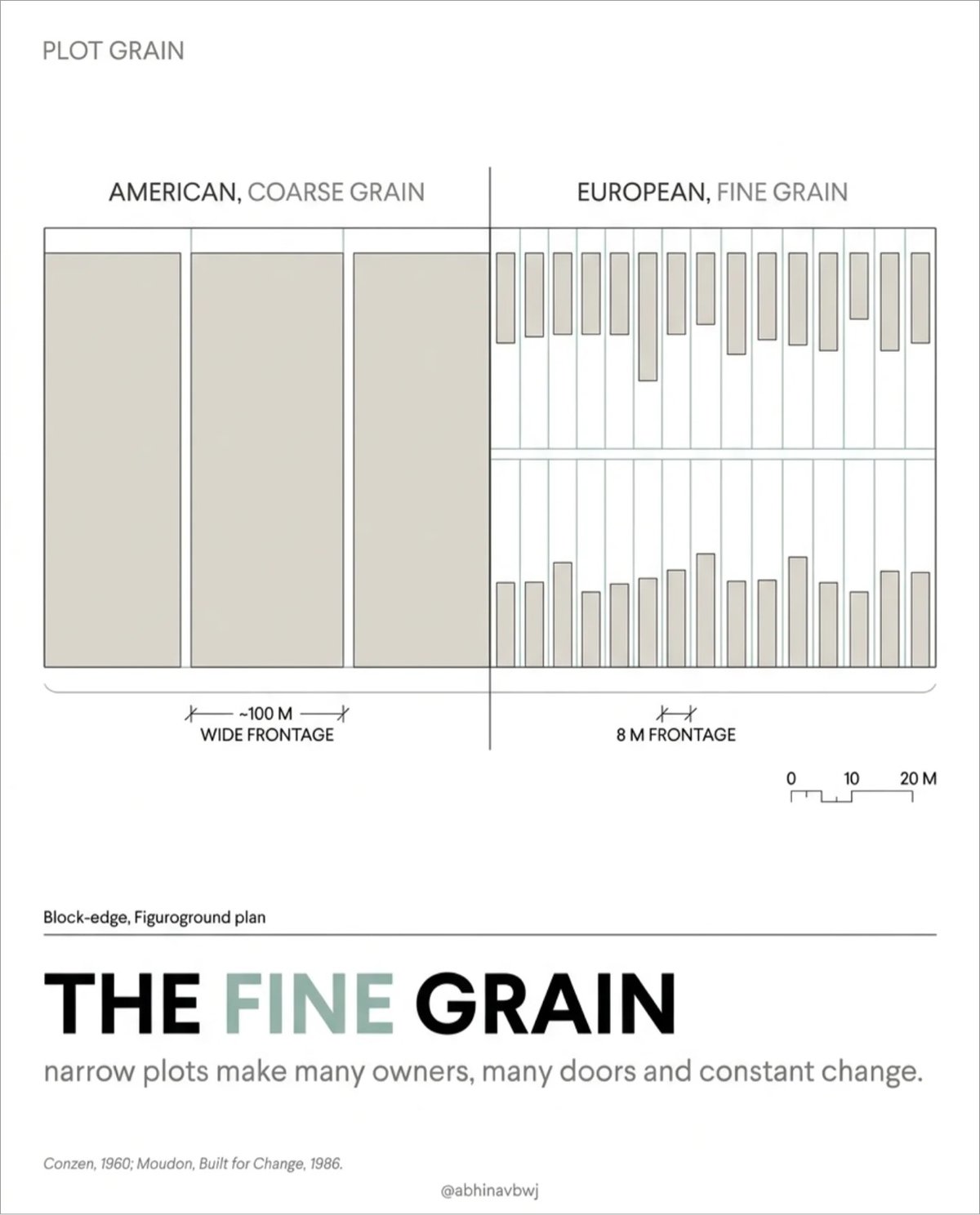
Architect and urban & computational designer Abhinav Bhardwaj made this great set of slides comparing urban design in the US and Europe, peppered with pithy observations like:
- European space is shaped on purpose: American open space is what’s left over.
- Small blocks make more corners, more routes, more street life.
- A fine grid offers hundreds of routes; the tree offers one way out.
(thx, meg)
This is an animated 3D visualization of the growth of Paris from 300 BCE to the present day. It was made with Blender (no AI) by Christian Ivan, who notes that it’s a “simplification” and so might not be 100% accurate. To my eye, the broad strokes are all there. The subtle sound design helps with the overall effect as well.

As part of a city-wide urban greening program, Taipei turned an abandoned football stadium into a community garden. Here’s an overview of the terraced garden that’s taken over Zhongshan Soccer Stadium from James Stewart on Instagram. A couple of screenshots from the video:

So cool! (thx, alaina)
From NY Times reporter Anna Kodé (whose “intersection of culture and real estate” reporting I’ve been enjoying lately), a short video on the increasingly hostile architecture of NYC.
The spread of the leaning bench and the lack of seating at places like Moynihan or around the city signals to homeless individuals that they are not welcome in these places. It signals to all New Yorkers that these are not social places. These are places to simply pass through.
Here’s a video Vox did on the subject seven years ago.
Being in Japan is offering me such a contrast to so many things in the US. There are benches in public places here and they don’t have spikes all over them. Japan has the world’s lowest rate of homelessness, probably because they take care of people.
In America, we don’t provide housing or much of anything else for people (including a living wage or affordable health care) and the result is that no one can sit down in Penn Station or in a subway station and oh by the way, lots of people have nowhere to live. Why do we do this to ourselves? We could live better lives but we choose not to….for reasons?
Direcciones is a short documentary about how giving directions works in Costa Rica, where “a centralized system for street addresses does not exist”. Instead, people use landmarks as reference points when giving directions. Here’s a postal worker talking about how some senders use outdated location markers to send letters:
Pretty bad, addresses here are pretty bad. For example, there is a letter I get, like, once a month. It says, “From the old Cristal Hotel…” and then some other reference points. So, yeah, it’s hard because people don’t update the addresses, they just write “from the old…” and it stays “from the old…” The Cristal Hotel had already closed when I was born.
However, for many residents there’s a kind of poetry in this old style of wayfinding. A lovely and thoughtful short film.

An article about The Quintessential Urban Design of ‘Sesame Street’ with a bunch of photos? This is extremely up my alley. One of the show’s big influences when it began was Jane Jacobs’ landmark book, The Death and Life of Great American Cities, which informed the set design:
“Even if you hadn’t read Jane Jacobs, that book was so huge that it was in the air,” said Benjamin Looker, who is the author of “A Nation of Neighborhoods” and an associate professor of American studies at Saint Louis University.
The show’s creators, he said, were “assimilating some of the popular notions that she put into play about the value of the sidewalk and street life.”
On Sesame Street, the stoop, the outdoor-dining space in front of Hooper’s convenience store, and Elmo’s wide-open window blur the boundaries between public and private space, fostering neighborly interactions between characters.
Street noises in the background and neighbors hollering through windows signal to viewers that this block is not a wealthy one. The streetscape, Mr. Looker said, “is an extension of people’s homes.”
A friend shared that they recently visited the Sesame Street set and that is something I would very much like to do someday.
I ran across this story from Vanessa Guerrero on Instagram recently. She originally posted it to Twitter a few years ago; here’s the full text:
Living in LA, I’ve lived in many a neighborhood in which police helicopters circle all day and they don’t do anything except be loud an annoying. You know what improved the morale and safety of my neighborhood in less than two weeks?
A new taco stand. I’m 1000% serious.
In general street food vendors on a block means more pedestrian foot traffic round the clock, if they’re open late, that’s more eyes in a neighborhood. Additionally in an area with many dark empty storefronts, literally adds light and vitality to the area.
More of the neighborhood is meeting each other waiting in line for nearby tacos. I met people three houses down I didn’t know. It feels like we’re all only now getting to know each other, over a torta and some soda.
They also posted up at a bus stop and out open until 2am. Meaning people waiting for a bus stop are not longer waiting alone in the dark. There’s a noticiable air of camaraderie, safety and enthusiasm.
Street vendors did more for our neighborhood than the city ever did.
City planners had left the area in disrepair. The vendors literally CLEANED THE BLOCK. THEY PICKED UP TRASH THE CITY NEGLECTS.
I’m serious when I say in the area they posted up, it’s markedly cleaner. This is not the work of the local waste removal services. This is taqueros.
I love this. In her book The Death and Life of Great American Cities, Jane Jacobs wrote about the importance of “having eyes on the street” and foot traffic to building successful neighborhoods:
A city street equipped to handle strangers, and to make a safety asset, in itself, out of the presence of strangers, as the streets of successful city neighborhoods always do, must have three main qualities:
First, there must be a clear demarcation between what is public space and what is private space. Public and private spaces cannot ooze into each other as they do typically in suburban settings or in projects.
Second, there must be eyes upon the street, eyes belonging to those we might call the natural proprietors of the street. The buildings on a street equipped to handle strangers and to insure the safety of both residents and strangers, must be oriented to the street. They cannot turn their backs or blank sides on it and leave it blind.
And third, the sidewalk must have users on it fairly continuously, both to add to the number of effective eyes on the street and to induce the people in buildings along the street to watch the sidewalks in sufficient numbers. Nobody enjoys sitting on a stoop or looking out a window at an empty street. Almost nobody does such a thing. Large numbers of people entertain themselves, off and on, by watching street activity.
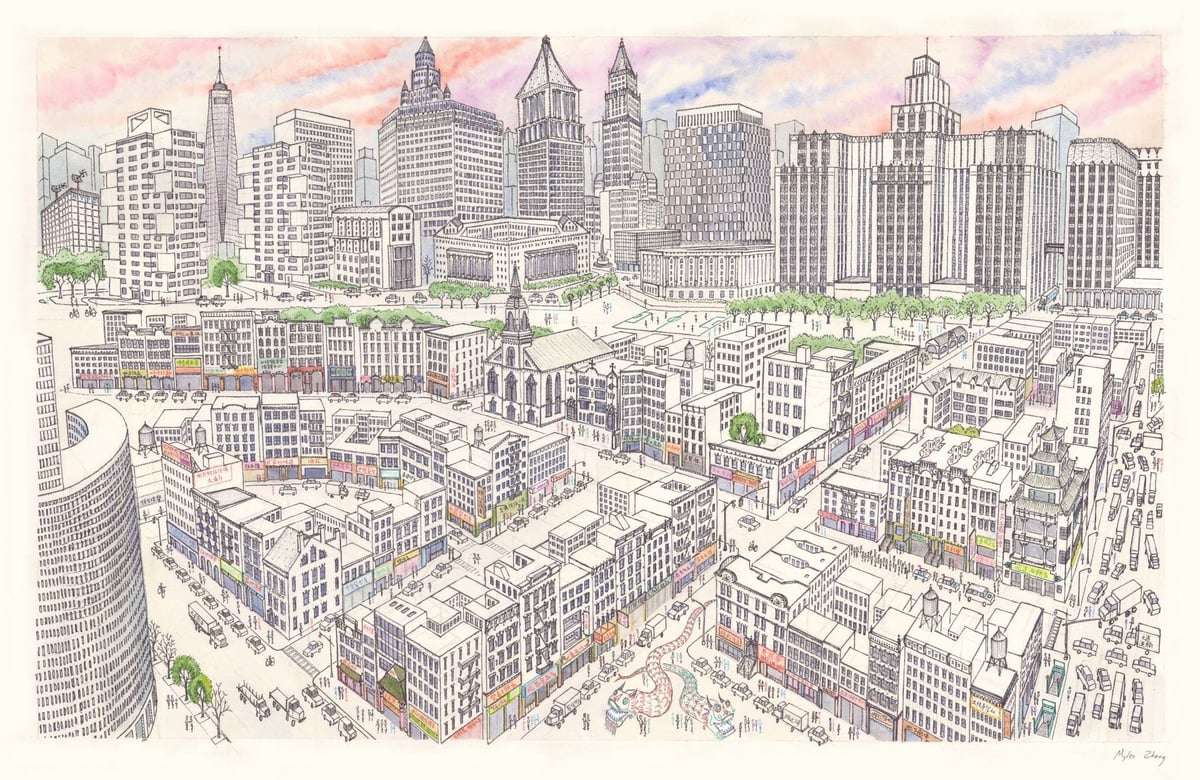
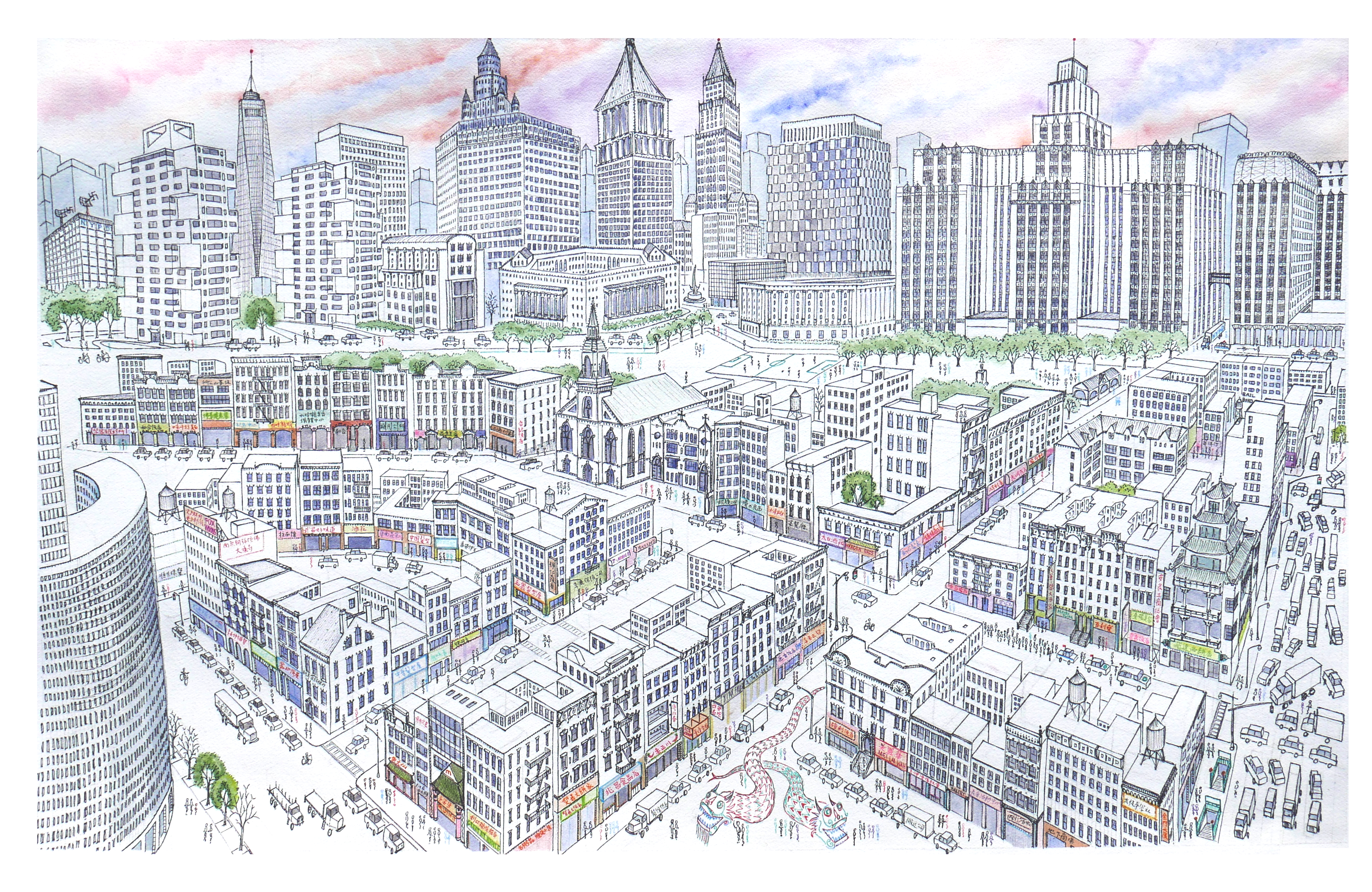
Myles Zhang, a PhD candidate in architectural history, created this drawing of Manhattan’s Chinatown several years ago.
Chinatown’s tenements are in the foreground, while the skyscraper canyons of Lower Manhattan rise above. This shows the area of Chinatown bordered by Bowery, Canal Street, and Columbus Park.
It took him around 60 hours to complete; he made a time lapse video of its creation:
There’s a very large scan of the image that’s worth looking at.
I’ve always been a little fascinated by the list of the largest cities throughout history, so this animated version from Ollie Bye is right up my alley. While watching, it’s interesting to think about what makes cities grow large at specific times: a mixture of economics, demography, social movements, empire/colonialism, technology, and the like.
Adam Yates travelled to Amsterdam to see how the Dutch have transformed the city and made it safer for people to get where they’re going more quickly. The phrase that grabbed me is:
Pedestrians, cyclists, and vehicles can all coexist without conflict, but only if they’re all going the same slow speed. This advances the principles of shared streets.
This is related to the Downs-Thomson paradox:
In simple terms, the Downs-Thomson paradox claims that traffic will increase without limit until the option of public transport (or any other form of transport) becomes faster than the equivalent trip by car. It draws the conclusion that people do not care whether they drive, walk, bike, or take the bus to any location — they just want to get from A to B in the fastest and most convenient way possible.
(via @marcprecipice)
Kyle Branchesi has created some fanciful “urban oddities” that imagine different locales in the UK being fully optimized for cars. For instance, here are Buckingham Palace and Westminster:
Writes Branchesi:
Amidst a political landscape where the ‘war on motorists’ is wielded as a populist tool, this series captures a future where this rhetoric has prevailed. The transformation of UK landmarks like Stonehenge into vast vehicular realms underscores the absurdity and danger of prioritizing short-term political gains over sustainable urban planning. These images mirror the contentious debates in the UK, challenging the narrative that prioritizes car ownership at the expense of public health and environmental sustainability.
Of course, in an America engineered by Robert Moses and his acolytes, many of those images don’t even look that far-fetched.
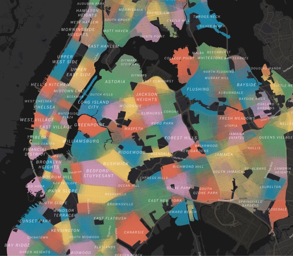
Using survey data, responses from community boards & city council members, and over 37,000 responses from NYC residents, a team at the NY Times has made a detailed map of the 350+ distinct neighborhoods in NYC. From a companion article:
It’s a New York pastime to gripe that neighborhoods are invented and defined by real estate brokers, developers and other city gatekeepers. But the more interesting truth may be that they are also reinvented and reinforced, refracted through race and class, by us: by the air traffic controller who lives in Little Yemen, by the Manhattan community manager who’s sure his constituents live in East Harlem — and not “Upper Carnegie Hill” — and by the Brooklyn residents who decided to name a relatively flat piece of land Boerum Hill.
A name has power. It can foreshadow who will be moving in. By itself, it can conjure so much: gentrification, displacement, inequality, status. When we argue over names, or even invent new ones, we may be trying to exert some of that power — or lamenting that others have more power than we do.
We asked New Yorkers themselves to map their neighborhoods and to tell us what they call them. The result, while imperfect, is probably the most detailed map of the city’s neighborhoods ever compiled.
The article is interesting throughout:
Our map reveals two main kinds of divisions: sharp ones and fuzzy ones.
The fuzzy ones often reflect areas in transition or dispute, where there’s no consensus or where gentrification is rewriting boundaries in real time.
The sharp ones often reflect features of the landscape itself: wide avenues, highways, remnants of canals. When you cross the street, you know you’re in another neighborhood.
Next time I’m in NYC, I’m definitely going to Little Yemen for lunch.
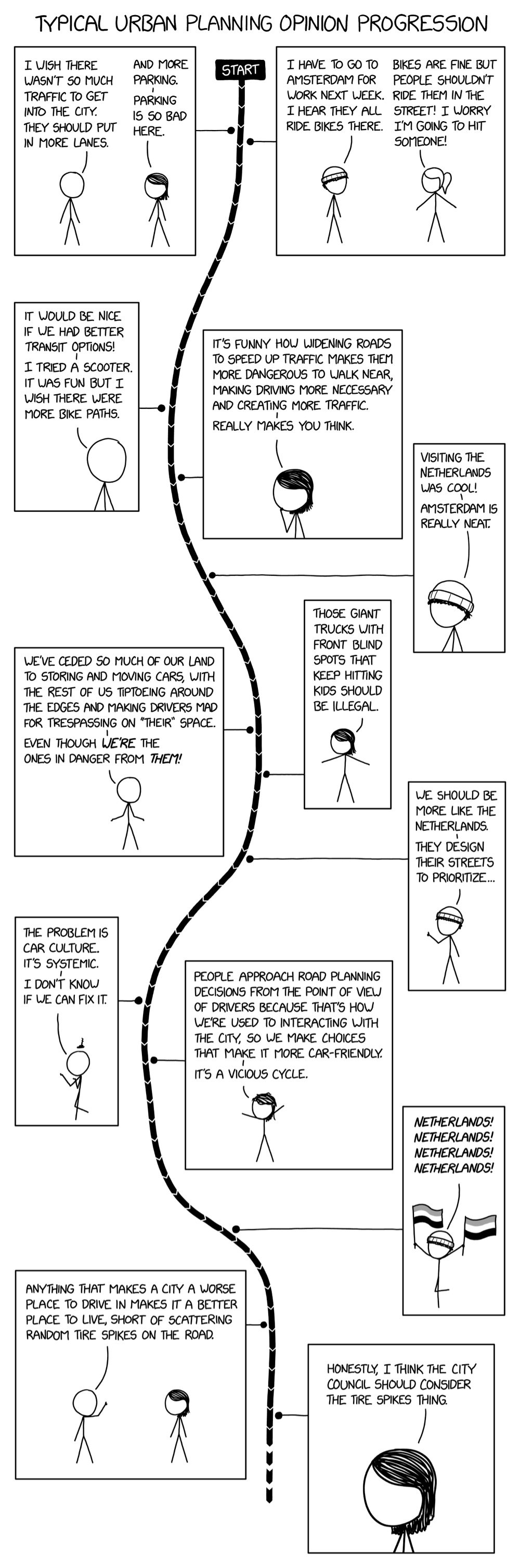
From XKCD, the progression of people’s opinions about cars & urban planning, from “I wish there wasn’t so much traffic to get into the city. They should put in more lanes.” to “Anything that makes a city a worse place to drive makes it a better place to live.” As The War on Cars said on Bluesky, “Randall Munroe, welcome to The War on Cars.”
P.S. Re: putting in more lanes, read up on induced demand and road dieting for why that’s often not a great idea.
European cities are transitioning to the use of cargo e-bikes and other micro-mobility solutions for package and other urban deliveries because they are safer, cleaner, and even faster in some cases than using vans or large trucks. The US isn’t making that same shift right now — this video from Vox explores why…and how we can move in that direction.
Fortunately, there’s a hero waiting in the wings: the e-cargo bike. Not only can these bad boys deliver packages in urban environments just as quickly (and sometimes faster) than delivery vans, they take up far less space and are much less likely to cause pedestrian deaths. Companies like Amazon, DHL, and UPS are using them in several European cities, but American cities haven’t followed suit.
In this video, we explore why that is, and lay out some of the big steps American cities would need to take to join the e-bike delivery revolution.
See also No Cars Allowed in This Swiss Town (Except Tiny Electric Ones).
From Adam Kovacs’ YouTube channel Adam Something comes this brisk 10-minute video essay on why European malls are doing better than their American progenitors. I thought his third point, about poor urban planning, was particularly interesting: malls tend to fail in America because they are not integrated into the fabric of towns and cities (because very little is integrated into the fabric of cities and towns in many places these days).
Malls, hell, all commerce has to be an organic part of towns and cities. People should be able to get to them by means other than a car, and conveniently. Such integrated commercial spaces are far more resilient. If your commercial spaces aren’t resilient — if you just plop a big box outside the town — don’t be surprised when it goes bust in a few years. And then it’s bulldozed for the next thing to be put up for it to go bust the same way and then get bulldozed and then the next thing and the next and the next so on and so forth.
This is something I’ve heard over and over again, in many cities around the world: putting in bike lanes in place of car parking and/or car lanes results in an increase in humans patronizing local businesses and increased sales.
Five years ago, the city of Queens, New York, announced that it would be putting bike lanes onto a stretch of Skillman Ave-and removing 116 parking spots. Cyclists loved the plan, but local business owners went ballistic. Taking out those parking spots, as they argued at protests and in letters to the city council, would devastate stores and restaurants along Skillman. “Parking here is already a nightmare,” one fumed at a protest rally.
But the bike lanes were a done deal, and soon they were in place. Early this year, Jesse Coburn — an investigative writer with Streetsblog New York — wondered whether those predictions of economic collapse came true. So he asked the city’s Department of Finance to give him a few years’ worth of sales figures for that stretch of Skillman Ave. How had the businesses on that street fared?
Quite well, it turns out. In the year after the bike lanes arrived, businesses on Skillman saw sales rise by 12 percent, compared to 3 percent for Queens in general. What’s more, that section of road saw new businesses open, while Queens overall had a net loss.
The thing is, the actual merchants along Skillman? They didn’t believe it. When Coburn spoke to them and described what he’d found, only a few store owners admitted the lanes had helped. Many still insisted the lanes were killing their part of the city. And emotions ran hot: Someone scattered tacks on the bike lane.
Back in August, David Zipper wrote an interesting piece for Slate arguing that urban areas should embrace smaller personal transportation options, like the golf cart.
Learnard said that most residents still commute by car, but that the carts have replaced automobiles for many short trips to a restaurant, school, or friend’s house. “Golf carts are a quintessential part of the quality of life here,” she said. “You put the family in a golf cart and go to the park or the splash pad. Or you go out for ice cream, or with your spouse to get a cocktail.” The golf carts have proved popular with teenagers; many use them to get to and from high school. Residents frequently personalize their vehicles with souped-up radios and jerry-rigged storage. “It turns out you can do a lot with a couple milk crates and bungee cords,” Learnard said.
With palpable enthusiasm, she reeled off a list of golf carts’ advantages over cars: They provide accessibility for residents who aren’t able to drive; they enable local shops to expand parking capacity (golf cart spots are significantly smaller than those for cars); the electric models are quiet and don’t pollute. She is even convinced that they have made her town friendlier. “If you’re on your golf cart and you see your neighbor doing yardwork, you’re going to pull over and chat,” she said. “You’re never going to do that if you’re in a car.”
Bikes and ebikes share many of these advantages and infrastructure built for bikes can often be used for carts and vice versa. Zipper followed up with a recent thread on how he saw golf carts being used in The Villages, FL and Peachtree City, GA.
The weather was awful when I stopped by The Villages, a fast-growing 60+ community in central Florida, but I still saw a ton of golf carts.
Put up some plastic sheets, and you’re protected from the rain.
The Villages was designed for golf carts; they can be life savers for those otherwise unable to drive.
Many roads have separated golf cart paths, and local streets are slow (with many roundabouts) so golf carts comfortably mix with car traffic.
I was skeptical but if you listen carefully, there are some really solid ideas in this video on why designing cities around lots of cars makes sense.
Brb, currently buying some cars and moving to cities.
In this video, using before-and-after satellite imagery, Claire Weisz of WXY, an architecture and urban design firm, explains how her company helped redesign three of NYC’s unruliest intersections: Astor Place, Cooper Union, and Albee Square. Unsurprisingly, the redesigns all involved taking space away from cars and giving it to larger sidewalks and more green space, to benefit people other than drivers.
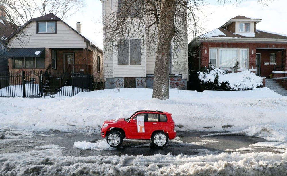
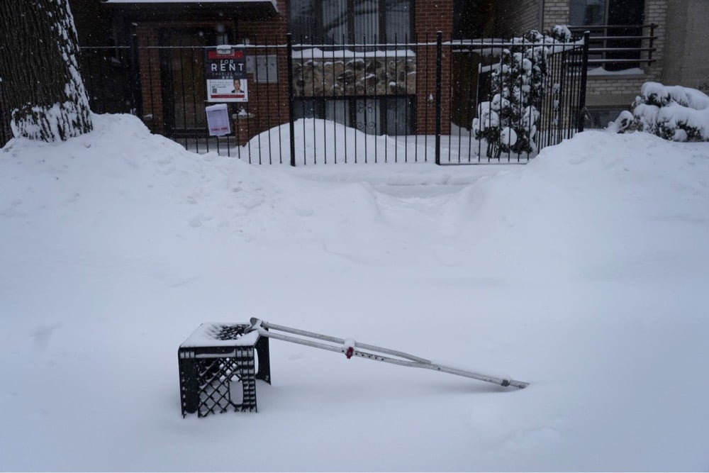
In major US metropolitan areas like Boston and Chicago that see significant winter snowfall, there’s a tradition of saving one’s shoveled-out street parking space with an object or objects that indicate to others that they should park elsewhere. After a big January storm, the Chicago Tribune posted a collection of photos of the best “parking dibs” in the city.
See also The Pittsburgh Parking Chair.
A group of Berlin residents has put forward a proposal to turn all of central Berlin (an area larger than Manhattan) into a car-free zone. What would that mean in practice? Adele Peters at Fast Company explains:
As in other cities, “car free” doesn’t literally mean that no cars could enter the area, but private car use would dramatically drop. Special permits would be given to emergency vehicles, garbage trucks, taxis, commercial and delivery vehicles (though many deliveries in Berlin already happen on cargo bikes), and residents with limited mobility who depend on cars. Others would be able to use a car, likely through a car-sharing program, up to 12 times a year to run longer errands. But most people, most of the time, would walk, bike, or take public transportation.
That sounds amazing and reasonable. There are five main goals the plan is trying to achieve for Berliners: better quality of life (walkable vibrant streets), better health (less pollution & noise), space for people (not vehicles), less climate impact, and street safety:
Berlin’s streets must become safer. There are still too many traffic deaths and injuries in Berlin. Especially the weakest must be protected: pedestrians and cyclists. Children and senior citizens in particular should be able to feel safe on Berlin’s streets; otherwise their mobility will be restricted because the risk or fear of an accident is too great.
The city is currently considering whether to turn the proposal into a law. This would be amazing to see in Berlin (and in some American cities too).
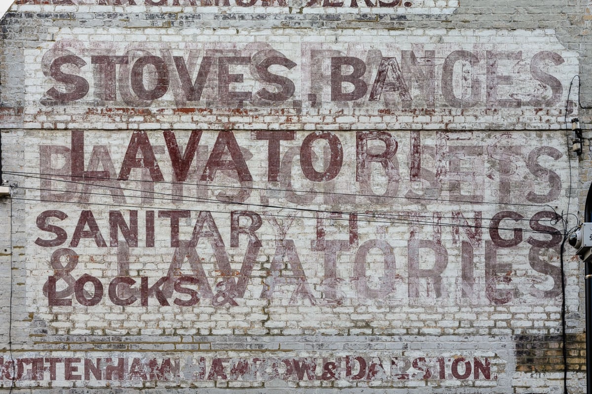
From Bloomberg’s CityLab:
Study the buildings flanking London’s older streets closely and you’ll see one soon enough: an old painted sign that, once bright and eye-catching, is now faded into the masonry, the name of the business or product it promoted flaking and faint.
Such “ghost signs” are fixtures of older neighborhoods in many cities around the world, but the U.K. capital, which bustled with competing commercial enterprises in the 19th and early 20th centuries, is unusually well-supplied with them. Ghost signs aren’t always easy to spot, but for sharp-eyed passersby and enthusiasts of urban history, they add an extra dimension to London’s appearance, their florid Victorian or cheerful art deco script and images a spectral reminder that once, not that long ago, these were somebody else’s streets.
London’s ghost signs are merely a fraction of the signage that used to greet 19th city dwellers, an era when cheap paper and a movement towards universal literacy made cities unusually alive with letters. But they are the special project of a new book by Sam Roberts and Roy Reed. From the book’s website:
Ghost signs are fascinating pieces of urban archaeology. Imposing yet hidden in plain sight, these faded advertisements are London’s history written on to the contemporary cityscape. They reveal fascinating stories of everyday life in the capital and each sign has its own tale to tell - not just of the business it represents and the people behind it, but of its own improbably survival.
A feast of history, typography and the urban environment, Ghost Signs: A London Story showcases London’s most impressive and historically significant faded painted signs, located, photographed and presented with archival andother contextual images.
Introduced by Wayne Hemingway MBE, the opening section shares insights into topics such as production techniques, economics and preservation. The themed chapters take on subjects including building, clothing, entertaining, branding and, ultimately, burying the city.
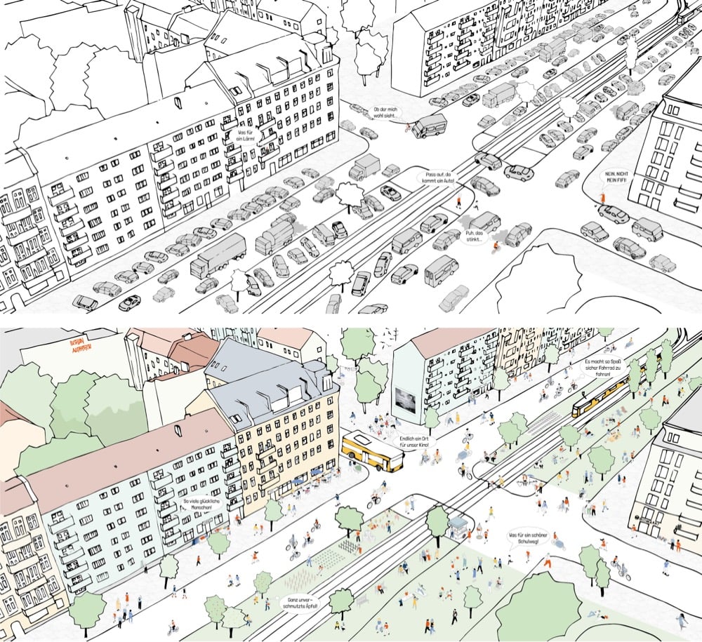
This video highlights one of the ways in which the Netherlands makes their streets safer for pedestrians: continuous sidewalks. Instead of sidewalks ending at the curb and picking up on the other side of the street, many sidewalks in Dutch cities continue across roadways, at the same height and using different surface materials, forcing cars to slow and signaling to drivers to be alert for pedestrians.
It’s hard to describe how much nicer it is to walk in an environment like this. It feels like the people walking are in control and that drivers are a guest in their environment, not the other way around.
(via @davidfg)
In The Hidden Melodies of Subways Around the World, the NY Times takes a look at an often overlooked aspect of transit design: the door closing sounds on the subway. My favorite door jingle is from the Paris Metro — I never knew where it came from:
In Paris, a simple “A” note plays as the doors shut. This is also a throwback, a sound that mimics the vibrations of a mechanical part that is no longer in use on any of the system’s trains. “But for a half century Parisians and visitors alike became used to that sound, so we decided to keep it, and recorded a synthesized version,” said Song Phanekham, a communications manager for the Paris transit system. “It’s a tribute to the heritage of the Paris Metro.”
In Tokyo, each station has its own custom jingle to signal departures. In Rio de Janeiro, the subway’s door chime pays homage to bossa nova. In Vancouver, the doors still close to a three-note sound that was recorded in the 1980s on a Yamaha DX7. (“The hallmark of any mid-80s pop song,” said Ian Fisher, manager of operations planning at British Columbia Rapid Transit Company.)
You can listen to more sounds of subway doors closing in these three videos recorded by Ted Green.
Update: Composer Minoru Mukaiya has made distinct door-closing jingles for each subway station in Tokyo.
(via waxy)
In the last decade, the number of pedestrians hit by cars in the United States has increased by almost 50%, even as that rate has decreased in Europe and other wealthy nations (“thanks primarily to new street and crosswalk designs, implemented in the belief that most road deaths are avoidable”). In a review of Angie Schmitt’s 2020 book Right of Way: Race, Class, and the Silent Epidemic of Pedestrian Deaths in America for the New York Review of Books, Peter Baker explores why America is increasingly hostile to pedestrians. Part of the reason is the rise of SUVs (and one would assume, trucks) in the US:
In the 1980s SUVs were a rarity. It was only in 2015 that they started outselling sedans. In 2018 they accounted for just under half of new vehicle sales, more than any other category of car. The height of American SUVs makes it harder for drivers to see pedestrians and means the hit comes higher on the body — and backed by extra mass — which makes organ damage and death two to three times more likely for adults, and four times more likely for children. More SUVs than ever are “overpowered” — that is, equipped with a high horsepower-to-weight ratio; this makes speeding more likely, which, like increased height and weight, increases the chances of pedestrians being hit and killed. More cars on the road, taller and heavier than ever before, going faster: each factor alone presents a serious problem. Together, they are a recipe for disaster.
And pedestrian deaths are also not equally distributed across population groups, both because of who owns cars but also shifts in where people are living:
Low-income pedestrians, Black and Hispanic pedestrians, elderly pedestrians, and disabled pedestrians are all disproportionately affected. Black and Hispanic men are twice as likely as white men to die while walking, and four times more likely than the average member of the population. Native American men are almost five times more likely.
The piece is interesting throughout, as is Schmitt’s book I’m sure.
From Electric Vehicles Won’t Save Us by Coby Lefkowitz:
This isn’t a story about Elon Musk, or Tesla, or a contrarian take about how “oil is good, actually.” I unconditionally support electric vehicles in their quest to take over the primacy of gasoline-powered vehicles in the market. But I don’t save that enthusiasm for their prospects on society broadly. From the perspective of the built environment, there is nothing functionally different between an electric vehicle and a gasoline propelled one. The relationship is the same, and it’s unequivocally destructive. Cars, however they’re powered, are environmentally cataclysmic, break the tethers of community, and force an infrastructure of dependency that is as financially ruinous to our country as it is dangerous to us as people. In order to build a more sustainable future and a better world for humanity, we need to address the root problems that have brought us to where we so perilously lie today.
Walking, cities, Paris, and YouTube are four of my favorite things, so this 5.5-hour, 12-mile video walking tour of Paris is right up my alley. Along the way, they visit the Notre Dame, the Arc de Triomphe, the market on Rue Mouffetard, the Jardins du Luxembourg, the Louvre, the Eiffel Tower, and lots more. If you turn the closed captions on, you can read about the histories of the places as the walk progresses. Hopefully this will tide me over until I can visit again. (via open culture)
The Artifact Artist is a short documentary about urban archaeologist Scott Jordan, who, over the past 50 years in NYC, has dug up all sorts of historical objects that date back decades and centuries, even all the way back to the Revolutionary War. The trailer is above and you can watch the entire short film on Vimeo.
Uprooted from the forests of Connecticut to move to New York City, 9 yr. old Scott Jordan declares “I won’t be a city kid!” 45 yrs. later Scott is an urban archeologist. An Indiana Jones in Gotham. Hand digging out centuries old privies, cisterns and landfills across the five boroughs Scott is uncovering artifacts and preserving New York City history by creating artifact art with the treasures he discovers.
Older posts
Socials & More