Some Tour de France fans have mapped
Some Tour de France fans have mapped the entire route of the 2006 Tour in Google Earth. (via airbag)
This site is made possible by member support. 💞
Big thanks to Arcustech for hosting the site and offering amazing tech support.
When you buy through links on kottke.org, I may earn an affiliate commission. Thanks for supporting the site!
kottke.org. home of fine hypertext products since 1998.
Beloved by 86.47% of the web.
Some Tour de France fans have mapped the entire route of the 2006 Tour in Google Earth. (via airbag)
A few months ago, I found a map online (which I cannot for the life of me relocate and I’m keen to find it again…any ideas? it’s from Bill Rankin’s The Errant Isle of Manhattan…see update below) of Manhattan pasted next to Chicago, as if the island had taken up permanent residence in Lake Michigan. Recently I decided to explore the unique aspect of Manhattan’s scale with a series of similar maps of places I’ve been to or lived in: Boston, Chicago, Minneapolis, San Francisco, and Barron, WI (my hometown). Manhattan Elsewhere is the result.
Depending on your vantage point, Manhattan seems either very big or very small. On complete map of the New York City area, Manhattan is dwarfed in size by the other four boroughs and surrounding megopolis. But for someone on the ground in Manhattan, the population density, the height of the buildings, the endless number of things to do, and the fact that many people don’t often leave their neighborhoods, much less the island, for weeks/months on end makes it seem a very large place indeed. This divergence sense of scales can cause quite a bit of cognitive dissonance for residents and visitors alike.
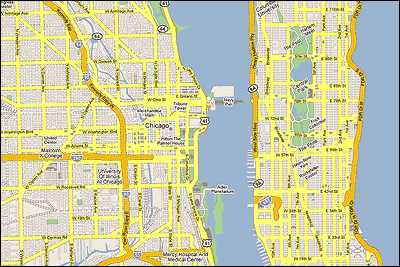
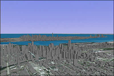
For the top image, I used the Google Maps representations of Manhattan and Chicago to create a composite map. In the bottom image, I used Google Earth’s 3-D views to create a approximate view of Manhattan from Chicago. In all cases, Manhattan is to scale with the other cities. Click through for larger images and other cities.
Update: The map on which Manhattan Elsewhere is based was done by Bill Rankin, who runs the excellent Radical Cartography site, and is part of The Errant Isle of Manhattan project. He also did maps for Boston, SF, Door County, WI, Philly, and Los Angeles (look at how gigantic LA is!), which I completely forgot about. He also made more of an effort than I did to connect the roads. (thx, zach)
Colorfully intricate maps of language distributions. The Asian and African maps are quite complex. (via moon river)
Satellite photo of a piece of San Francisco “healing around now-gone railroad tracks”.
Google Maps + Fast Food shows all the the McDonald’s, Burger Kings, Wendy’s, and Jack in the Boxes in the US on a scrollable, zoomable map. Here’s lower Manhattan + parts of Brooklyn and New Jersey. (Alternate plurals of Jack in the Box: Jacks in the Box or Jack in the Boxen?)
3-D NYC buildings from Google Earth (extracted with OGLE) printed out on a 3-D printer.
Interactive map (powered by, what else, Google Maps) showing which area will be flooded when the sea level rises. Here’s what parts of Manhattan, Brooklyn, and Queens will look like if the sea level rises 7 meters.
ASCII Maps, a fully-functional version of Google Maps represented in ASCII. Doesn’t work in Safari tho. (via infosthetics)
In March of 2004, an artist named Tofu began constructing a map comprised only of the hometowns of American men and women killed in Iraq (map detail). “One of the disturbing by products of this work are the maps of various states with many rectangular pieces missing where I cut out towns.” (via moon river)
BLDGBLOG posts a series of maps showing how, through the movement of the earth’s tectonic plates, North America came to its present position and shape. Full set of maps here.
Update: Mike Migurski combined the maps into an awesome movie spanning 550 million years. It’s….wait for it…..the longest movie ever made!
Even native New Yorkers are often disoriented when exiting subway stations, so why doesn’t the MTA print a little direction indicator on the pavement near the exits? Better yet, download the stencils provided here and let’s do it ourselves.
A world map with the current locations of hundreds of ships. Fascinating. Look at how crowded the vast Pacific is.
Representation of the London Tube map if the stations were sponsored by products or companies. I love the Pizza Hutney, Upministry of Sound, and iPoddington stops. Rather DFWesque. (via bb)
Infographic of the connections between “3 celebrities, 35 corporations, 40 subsidiaries and more than 300 brands”. For a closer look, check out the larger version.
Dorian Lynskey “[charted] the branches and connections of 100 years of music using the London Underground map”, much like Simon Patterson’s The Great Bear. (gs)
Neat “center of gravity” calculator for Google Earth. Inspired by Cory’s map of the center of gravity of Manhattan’s Starbucks.
Ian Albert collects really large digital images (100-900 megapixels) and constructs maps of video game worlds, including Super Mario Bros and The Legend of Zelda. (via lia)
Eyebeam’s Mike Frumin has released OGLE (OpenGL Extrator), a software package for extracting 3-D data from Windows applications. This means you can do stuff like grab the 3-D likeness of your World of Warcraft character and print it out on a 3-D printer or insert him into a Manhattan landscape (grabbed from Google Earth). Announcement here.
A recently unveiled Chinese map — a reproduction of a 1418 map — may show that the Chinese discovered the Americas more than 70 years before Columbus. There is, however, some question about the map’s authenticity.
This blog cites a Target store advertising on Google Maps (by painting their logo on the roof), but it’s more likely that the bullseye is there for the benefit of airline passengers landing at nearby O’Hare (as this slightly wider view shows). (via bb)
Cory has calculated the center of gravity of Starbucks in Manhattan…that is, the geographic point where all of them are pulling equally on you. It’s right around 40th St and 5th Ave.
A world map of cultural prejudices, compiled by asking Google what different cultures “are known for”. (via waxy, who is known for good links)
If you’re looking for a Christmas tree in NYC, here’s a map of where they’re sold. (via sbj)
Wow, an interactive transit map for NYC. I haven’t kept up with all the Google/Yahoo Maps subway mashups, but this one is pretty impressive. Click start and end points and it tells you which subway to board and how long the trip will take, including walking time.
Good maps of Bangkok seem hard to come by. Before we left, we looked in several bookstores and decided on The Rough Guide to Bangkok. We’d never used a Rough Guide before but our usual (excellent) guidebook series, DK Eyewitness Guides, did not have a Bangkok-specific book, only a general Thailand guide. What a mistake…I’ve wanted to throw the RG right into the river about 10 times in the past few days. Meg promises me that once we get home, I can ritually set fire to it and cleanse ourselves of its crappiness.
On one of our last days here, we happened upon the Eyewitness Guide for Thailand and while it’s thick and heavy, the Bangkok section would have been perfect for our needs. Argh! Oh well…one of the difficulties in traveling is that you never know what you’re really going to need until you get to where you’re going, and that goes double for maps.
We ended up relying quite a bit on the free SkyTrain/Metro map they give you at the station, as well as a slew of free maps available at our hotel and various other places around town. None of them was very good, but depending on what we were doing, one of them had the appropriate information on it. After all this, I wonder if a good map for Bangkok even exists[1]. The city is so big and sprawling that it’s conceivable that no one has undertaken the effort to map it all.
[1] To its (possible) credit, the RG recommended a Bangkok map called Nancy Chandler’s Map of Bangkok. We found it in a small bookshop on our last full day here, and while we couldn’t properly evaluate it in its wrapper, it looked promising.
Ok, one last wrap-up post about Hong Kong and then we’re focusing on the matter at hand in Bangkok (short summary: having a great time so far here). So, three things I really liked about/in Hong Kong and then some miscellaneous stuff.
1. Octopus cards. I really can’t say enough about how cool these cards are. Wikipedia provides a quickie definition: “The Octopus card is a rechargeable contactless stored value smart card used for electronic payment in online or offline systems in Hong Kong.” It’s a pay-as-you go stored value card…you put $100 bucks on it and “recharge” the card when it’s empty (or when it’s even more than empty…as long as your balance is positive when you use it, you can go into a HK$35 deficit, which you pay when you recharge the card). You can use it on pratically any public transportation in the city: buses, trains, MTR, trams, ferries, etc. It works with vending machines, at 7-Eleven, McDonald’s, Starbucks, and the supermarket. You don’t need to take it out of your wallet or purse to use it, just hold it near the sensor. Your card is not tied to your identity…there’s no PIN, you can pay cash, they don’t need to know your credit card number, SS#, or anything like that. They even make watches and mobile phones that have Octopus built it, so your phone (or watch) becomes your wallet. Mayor Bloomberg, if you’re listening, NYC needs this.
2. The on-train maps for the MTR. Here’s a (sort of blurry) photo (taken with my cameraphone):
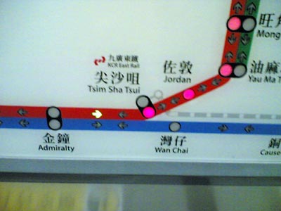
The current stop blinks red — in this case, Tsim Sha Tsui (blinking not shown, obviously) — with the subsequent stops lit in red. If the next stop connects to another line, that line blinks as well. A small green arrow indicates which direction you’re traveling and there’s an indictor (not shown) which lights up either “exit this side” or “exit other side” depending which way the doors are going to open. Great design.
3. Muji! We located one in Langham Place (an uber-story mall) in Mong Kok (for reference, the store in Silvercord in TST listed on their site has closed). Muji is kind of hard to describe if you’ve never been to one of their stores before (and if you live in the US, you probably haven’t because they’re aren’t any, aside from a small outpost in the MoMA Store). Adam (see previous link) roughly translates the name as “No Brand, Good Product”, so you can see why I like it so much. They sell a wide variety of products (take a look at their Japanese-only online store for an idea of what they carry); at the Monk Kok store, they had snacks & drinks, some furniture (made out of sturdy cardboard), their signature pens and notebooks (a display of the former was completely surrounded by a moat of teenaged girls, so much so that I didn’t get a chance to test any of the super-thin pens), some clothes (including some great pants that they didn’t have in anything approaching my size), dishes, cosmetics, bath products, and containers of all shapes, sizes, and uses. I wanted one of everything, but settled for a couple of shirts (with absolutely no logos or markings, inside or out, to indictate that they are Muji products).
m1. Big Buddha, worth the trip. It’ll better when the tram from Tung Chung and back is built, although then you’ll miss the boat ride (fun) and the bus ride (harrowing at times).
m2. The Peak Tram. Touristy, but also worth the trip. The weird/ugly anvil-shaped building at the top is currently under construction, so the views will be much better when its finished. Go at night for the best view.
m3. The view from the waterfront in Kowloon of the Hong Kong skyline at night is one of the best in the world.
m4. Speaking of, Hong Kong is a night-time city. All the buildings are lit up, there’s a nightly light show at 8pm (think Laser Floyd without the music), and buildings that appear monolithic in the daytime transform at night, either by disappearing into the darkness while leaving a graceful trace of their outline or acting as huge screens for projected light shows. Reminded me of Vegas in this respect.
m5. We had tea in the lobby of the InterContinental Hotel (go for the view, it’s incredible) and the live band played the theme song from The Lord of the Rings. I tried to get a recording of it with my phone (iPod was back in our hotel room), but it didn’t turn out so well. Very weird; we were cracking up and expecting the theme from Superman or even 3’s Company to follow.
m6. Oh, I’m sure there’s more, so I’ll add it here as I think of stuff.
Beautiful flight pattern visualizations over the US based on data from the FAA. (via ia)
New version of Yahoo Maps catches up to Google Maps and does them one or two better. Quite the homage, though. (via df)
Socials & More