



Hong Kong wrap-up
Ok, one last wrap-up post about Hong Kong and then we’re focusing on the matter at hand in Bangkok (short summary: having a great time so far here). So, three things I really liked about/in Hong Kong and then some miscellaneous stuff.
1. Octopus cards. I really can’t say enough about how cool these cards are. Wikipedia provides a quickie definition: “The Octopus card is a rechargeable contactless stored value smart card used for electronic payment in online or offline systems in Hong Kong.” It’s a pay-as-you go stored value card…you put $100 bucks on it and “recharge” the card when it’s empty (or when it’s even more than empty…as long as your balance is positive when you use it, you can go into a HK$35 deficit, which you pay when you recharge the card). You can use it on pratically any public transportation in the city: buses, trains, MTR, trams, ferries, etc. It works with vending machines, at 7-Eleven, McDonald’s, Starbucks, and the supermarket. You don’t need to take it out of your wallet or purse to use it, just hold it near the sensor. Your card is not tied to your identity…there’s no PIN, you can pay cash, they don’t need to know your credit card number, SS#, or anything like that. They even make watches and mobile phones that have Octopus built it, so your phone (or watch) becomes your wallet. Mayor Bloomberg, if you’re listening, NYC needs this.
2. The on-train maps for the MTR. Here’s a (sort of blurry) photo (taken with my cameraphone):
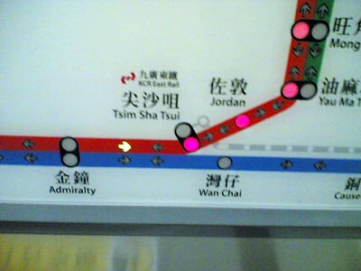
The current stop blinks red — in this case, Tsim Sha Tsui (blinking not shown, obviously) — with the subsequent stops lit in red. If the next stop connects to another line, that line blinks as well. A small green arrow indicates which direction you’re traveling and there’s an indictor (not shown) which lights up either “exit this side” or “exit other side” depending which way the doors are going to open. Great design.
3. Muji! We located one in Langham Place (an uber-story mall) in Mong Kok (for reference, the store in Silvercord in TST listed on their site has closed). Muji is kind of hard to describe if you’ve never been to one of their stores before (and if you live in the US, you probably haven’t because they’re aren’t any, aside from a small outpost in the MoMA Store). Adam (see previous link) roughly translates the name as “No Brand, Good Product”, so you can see why I like it so much. They sell a wide variety of products (take a look at their Japanese-only online store for an idea of what they carry); at the Monk Kok store, they had snacks & drinks, some furniture (made out of sturdy cardboard), their signature pens and notebooks (a display of the former was completely surrounded by a moat of teenaged girls, so much so that I didn’t get a chance to test any of the super-thin pens), some clothes (including some great pants that they didn’t have in anything approaching my size), dishes, cosmetics, bath products, and containers of all shapes, sizes, and uses. I wanted one of everything, but settled for a couple of shirts (with absolutely no logos or markings, inside or out, to indictate that they are Muji products).
m1. Big Buddha, worth the trip. It’ll better when the tram from Tung Chung and back is built, although then you’ll miss the boat ride (fun) and the bus ride (harrowing at times).
m2. The Peak Tram. Touristy, but also worth the trip. The weird/ugly anvil-shaped building at the top is currently under construction, so the views will be much better when its finished. Go at night for the best view.
m3. The view from the waterfront in Kowloon of the Hong Kong skyline at night is one of the best in the world.
m4. Speaking of, Hong Kong is a night-time city. All the buildings are lit up, there’s a nightly light show at 8pm (think Laser Floyd without the music), and buildings that appear monolithic in the daytime transform at night, either by disappearing into the darkness while leaving a graceful trace of their outline or acting as huge screens for projected light shows. Reminded me of Vegas in this respect.
m5. We had tea in the lobby of the InterContinental Hotel (go for the view, it’s incredible) and the live band played the theme song from The Lord of the Rings. I tried to get a recording of it with my phone (iPod was back in our hotel room), but it didn’t turn out so well. Very weird; we were cracking up and expecting the theme from Superman or even 3’s Company to follow.
m6. Oh, I’m sure there’s more, so I’ll add it here as I think of stuff.
Socials & More