Hurricane Sandy is (almost) here
It’s about 1:30 pm here in NYC and we’re starting to see the effects of Hurricane Sandy. Rivers are overflowing their banks, wind is whipping, and residents are either hunkered down or scurrying around picking up last minute supplies. I’ll be updating this post when I can, here and there, during the course of the day.
Updated Mon 7:42pm ET:
Kids are way worse than the hurricane today. FEMA, NYPD, FDNY, need emergency parental evac now!
What to Expect at Landfall in Next Two Hours (WSJ):
The storm’s quicker-than-expected forward motion means it will make landfall about two hours sooner than previously anticipated. Landfall is now expected around 6 p.m. this evening, near or just south of Atlantic City, N.J. This doesn’t change the forecast much for coastal New Jersey, but it could greatly complicate coastal flooding projections for New York Harbor.
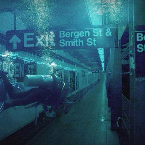
Whoa, it looks like the situation in the Brooklyn subway is getting dire:
Twitter has compiled a list of hurricane resources on Twitter.
Here’s a close-up photo of that crane that’s dangling from that building on 57th Street. CBS has a live view of the crane.
Not from The Onion, but this report on how Williamsburg residents are coping with the storm sure reads like it:
“I just got these kick-ass new stereo speakers and I am going to listen to those until the power runs out,” Jim Butler, another Edge resident, said, tugging on the doors of the CVS that is part of the complex-it had just closed a few minutes before 5 p.m. “Then I’m going to read and look at my art books. I’ll live by candlelight, get in touch with my 19th century self.”
From just now on the TV: Con Ed has taken down the Bowling Green and Fulton electrical networks in lower Manhattan. Likely area hit is “east of Broadway btwn Wall St & tip of Manhattan & from Frankfort to Wall btwn William St & East river.”
Water level at the Battery has hit 11.25 ft, breaking a record set in 1821.
Updated Mon 4:08pm ET:
Tweet from Jen Bekman:
[Con Ed] rep on NY1 sayspower shutdown “very likely” south of 34th st. 7-9pm for high tide.
Some common sense tips: how to make your cell phone charge last if the power goes out.
Walked by Joseph Leonard on Waverly Place here in the West Village earlier and it was jam packed.
Want to look at a bunch of good photos of the hurricane? Alan Taylor at In Focus has you covered.
Great story of how Dan Rather hacked up the first radar image of a hurricane shown on TV for Hurricane Carla in 1961.
He took a camera crew to the U.S. Weather Bureau (now the National Weather Service) office in downtown Galveston, which featured a cutting-edge WSR-57 radar console. He convinced the bureau staff to let him broadcast, live, from the office. He asked a Weather Bureau meteorologist to draw him a rough outline of the Gulf of Mexico on a transparent sheet of plastic; during the broadcast, he held that drawing over the computer’s black-and-white radar display to give his audience a sense both of Carla’s size and of the location of the storm’s eye. As CBS plugged into the broadcast, that audience suddenly became a national one.
Tappan Zee Bridge closed as of 4pm. And all bridges/tunnels in and out of Manhattan are closing at 7pm…or so I’ve heard on TV/Twitter. Is that right? Has anyone seen the Batman?
Things aren’t looking good on Nantucket. And probably not even close to max storm surge.
Updated Mon 3:47pm ET:
There are reports of a crane collapse at One World Trade but Jake Dobkin doesn’t see any evidence of that. (Update: Jake was right…no crane issue at 1WTC.)
Updated Mon 3:11pm ET:
More footage of the 1938 hurricane that hit the northeastern US.
Updated Mon 3:07pm ET:
Is TV news and Twitter whipping everyone into a hurricane-like froth with its incessant coverage of Sandy? Well, E.B. White has similar complaints about radio and Hurricane Edna back in 1954.
The radio either lets Nature alone or gives her the full treatment, as it did at the approach of the hurricane called Edna. The idea, of course, is that the radio shall perform a public service by warning people of a storm that might prove fatal; and this the radio certainly does. But another effect of the radio is to work people up to an incredible state of alarm many hours in advance of the blow, while they are still fanned by the mildest zephyrs.
That awesome photo you saw of Hurricane Sandy? It might not be Hurricane Sandy.
Vintage newsreel footage of hurricanes in 1938, 1955, and 1969.
Piers Morgan spotted a crane that has buckled on a building near CNN HQ in NYC (157 West 57th):
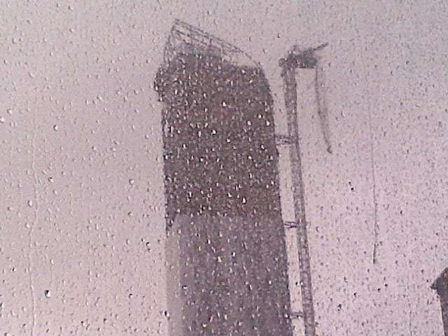
Massive bang and this giant skyscraper crane outside my office just buckled… Scary.
Updated Mon 2:19pm ET:
Lots of people have noted this feed of hurricane-related photos on Instagram.
NYC mayor Michael Bloomberg urges residents to “Have a sandwich out of the fridge. Sit back, and watch the television.” I am so there, Mr. Mayor.
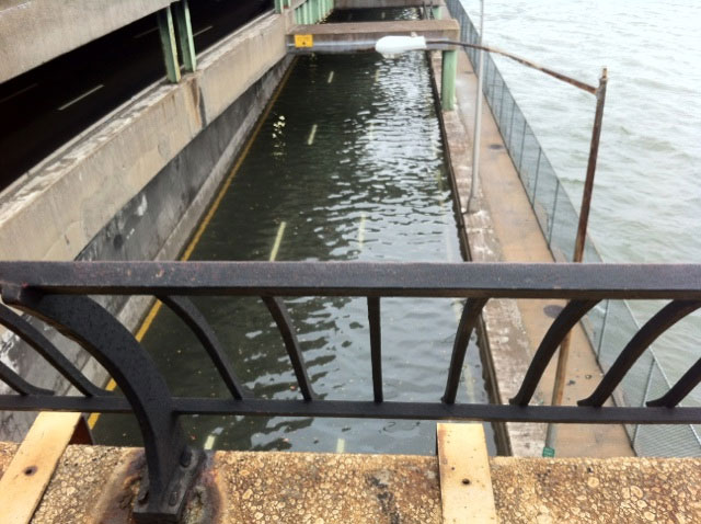
The lower level of FDR Drive on the east side of Manhattan is underwater:
The storm surge in New York Harbor is getting serious.
Con Ed just called us saying that they might have to shut off our power. No timeline mentioned.
Climate change has not been an issue at all in the 2012 Presidential election. Elizabeth Kolbert says that’s “grotesque”.
BTW, Mitt Romney wants to shut down FEMA and have the states fend for themselves. United(?) States of America?
Earlier:
This WSJ comparison of 2011’s Hurricane Irene and Sandy really captures just how massive this storm is and why people seem more concerned about it than they were with Irene.
Via Jeff Masters, Sandy is already producing record storm surges:
The National Weather Service in Atlantic City, NJ said that isolated record storm surge flooding already occurred along portions of the New Jersey coast with this morning’s 7:30 am EDT high tide cycle. As the tide goes out late this morning and this afternoon, water levels will fall, since the difference in water levels between low tide and high tide is about 5’. However, this evening, as the core of Sandy moves ashore, the storm will carry with it a gigantic bulge of water that will raise waters levels to the highest storm tides ever seen in over a century of record keeping, along much of the coastline of New Jersey and New York. The peak danger will be between 7 pm - 10 pm, when storm surge rides in on top of the high tide. The full moon is today, which means astronomical high tide will be about 5% higher than the average high tide for the month, adding another 2 - 3” to water levels.
The Holland Tunnel and the Brooklyn Battery Tunnel will be closing at 2pm today.
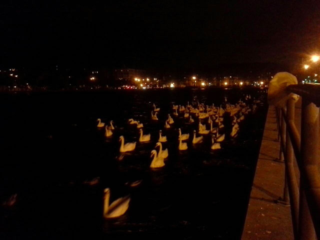
The swans are leaving Sheepshead Bay in Brooklyn:
Here’s a satellite view of Sandy developing near the equator and building in strength as it churns through the Caribbean and up the Atlantic coast:
Here’s my post from yesterday with all sorts of hurricane resources, including Jeff Master’s WunderBlog, the Wind Map, and check out your flood zone in NYC.
Socials & More